Demonstration on open data

Environmental baseline map for an impact assessment, around a fictitious site

The natural and heritage designations around a project site, inventoried in two study areas and brought together on an A3 map, from sources that all allow commercial use.
This is not a client assignment: I built it on public data to show engineering and environmental consultancies how I work as a subcontractor.

Context
Demonstration built on open data, not commissioned by a client. The project site is fictitious: an 8 ha rectangle in the Haut-Doubs (France), outside any protected area.
Study areas
Close: 2 km. Wider: 10 km.
Data
INPN via the Géoplateforme (ZNIEFF, Natura 2000, biotope protection orders, regional nature park); BD TOPAGE® 2024 (Sandre); DREAL Bourgogne-Franche-Comté (listed sites, water catchment areas); IGN. All under Licence Ouverte 2.0.
Tools
QGIS 3.44, Python (PyQGIS), GeoPackage

The consultancy's problem

The baseline chapter of an impact assessment always starts with the same map: what is protected or inventoried around the site. It takes time, and a misread licence can make it unusable.

The consultancy wants an accurate, sourced map, ready to deliver, with the inventory figures that go with it.

What the demonstration shows

  1. Gather. Designations from the official services (WFS), checking for each one that the licence allows commercial use.
  2. Inventory. For each type of designation: count in each study area and distance from the site to the nearest one.
  3. Map. An A3 map readable in black and white, with both study areas and a legend by type of designation.

Results

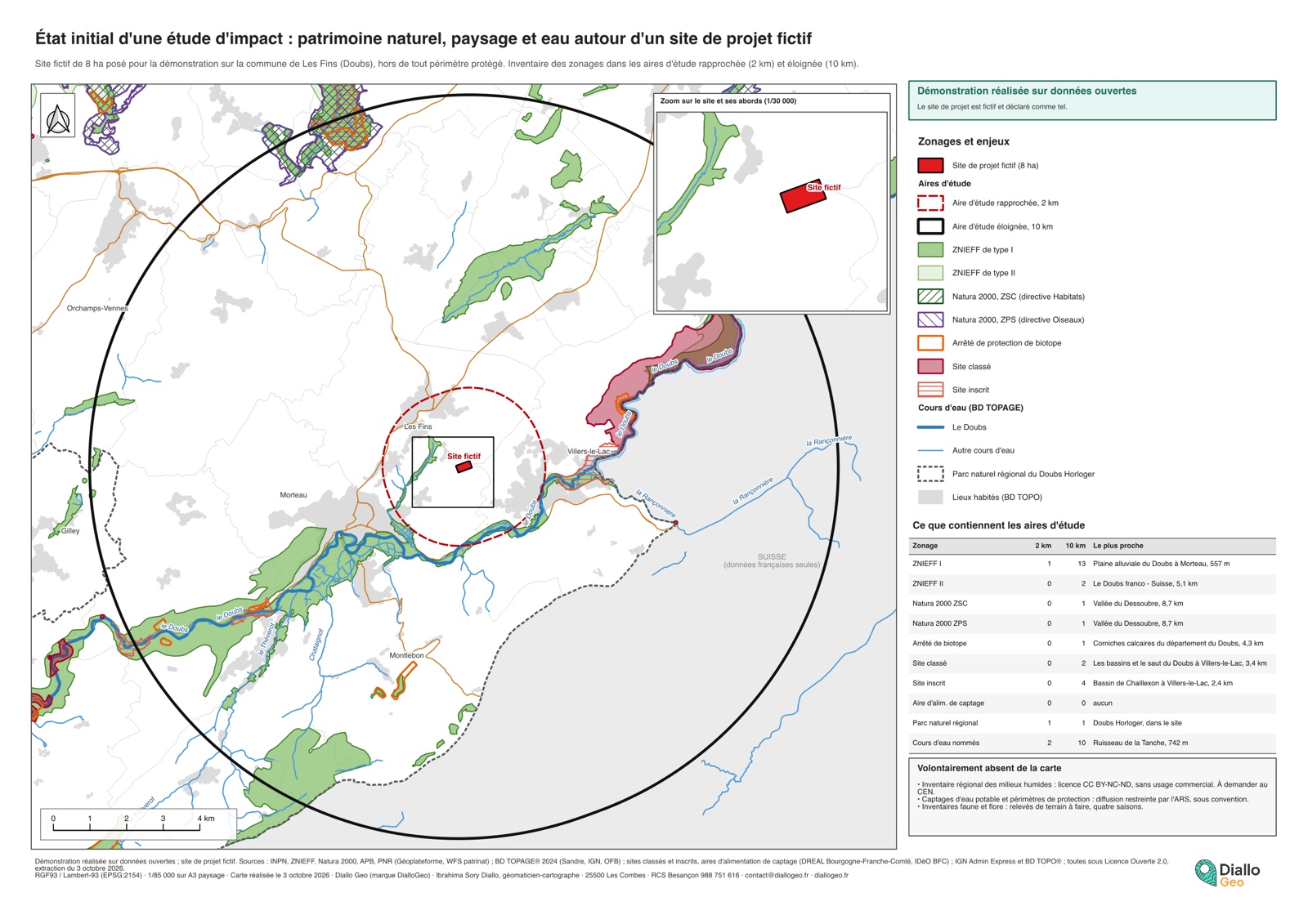
A3 baseline map: fictitious project site, 2 and 10 km study areas, ZNIEFF, Natura 2000, listed sites, watercourses
Sheet of the demonstration (A3, reduced). In French. Open the image full size
Download the sheet (PDF, in French), 1.0 MB

35designations and watercourses found within the 10 km study area, regional nature park included

  • Type I ZNIEFF13one 557 m from the site, in the close study area
  • Type II ZNIEFF, Natura 2000, biotope52 type II ZNIEFF, 1 SAC, 1 SPA, 1 biotope order
  • Listed sites62 classified, 4 registered, the nearest 2.4 km away
  • Watercourses (BD TOPAGE)102 of them in the close study area

The site lies within a regional nature park. No water catchment area within 10 km. Two sources were left out on purpose: the regional wetland inventory, under a non-commercial licence, and the drinking-water protection areas of the health agency, which are not public.

What I deliver

Limits

The map lists public designations: it does not replace the field surveys (fauna, flora, wetlands) of the impact assessment. Designations are those of the extraction date.

GIS back-up for your consultancy

I work as a subcontractor: data structuring and quality checks, maps and atlases, in your house style and under your name if you wish. QGIS, GeoPackage and PDF deliverables.

Discuss a project →

Reply within 24 business hours, quote within 3 business days.

← All case studies and demonstrations