Case study · Local authorities
Public car parks and flood risk in Bernis
The town's 13 public car parks, checked against the Vistre flood risk prevention plan and the terrain: 4 are floodable, 8 need monitoring and only one can serve as a refuge.
Case study · Local authorities
The town's 13 public car parks, checked against the Vistre flood risk prevention plan and the terrain: 4 are floodable, 8 need monitoring and only one can serve as a refuge.
Bernis is a town of 3,425 inhabitants in the heart of the Vistre basin, in the Gard département. Its historic centre was built at the foot of the hills, on the low land of the alluvial plain, and is covered by the Vistre flood risk prevention plan (plan de prévention du risque inondation, PPRi), approved on 4 April 2014.
When a flood warning is issued, the town needs to know which car parks to clear first and which ones can take the vehicles moved to safety. This feeds directly into its municipal emergency plan (plan communal de sauvegarde, PCS).
I carried out this study on my own initiative, to test on a real town a method designed for the 42 municipalities covered by the basin authority.
Which public car parks in Bernis are floodable, which need monitoring, and which can serve as a refuge during a flood?
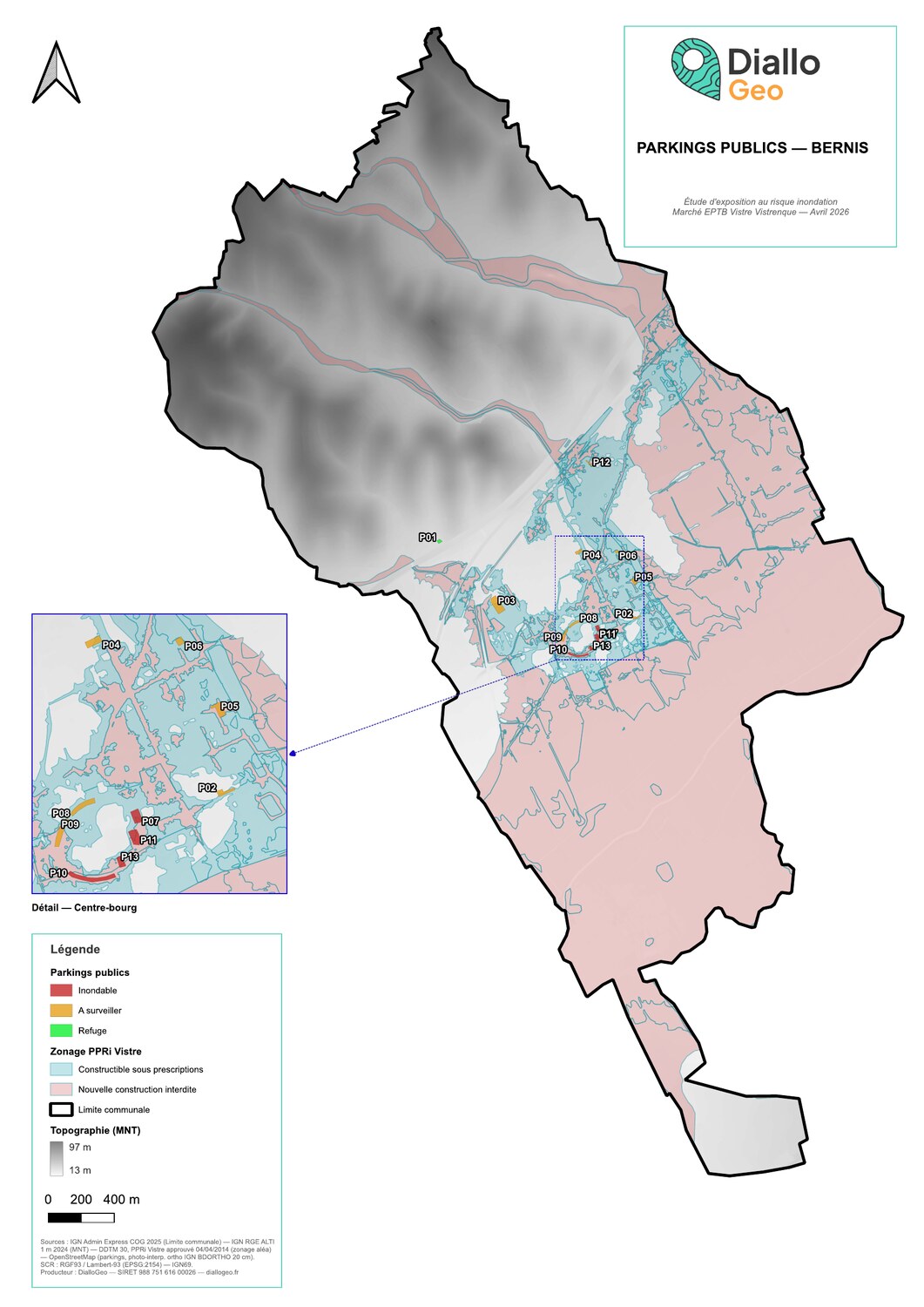
13public car parks analysed: 361 spaces over 12,948 m²
97% of the spaces lie in a PPRi hazard zone, 22% in a high-hazard zone. Only 12 spaces out of 361 (3%) are in a refuge zone: a single car park, Chemin des Capitelles, on the northern hills at 29.4 m (NGF datum). The four floodable car parks are all on the plain, between 20.0 and 20.8 m.
The Boulevard Alexandre Ducros car park (P10) combines every weakness: high-hazard PPRi zone, a mean elevation of 20.02 m, the lowest in town, and 30 spaces over 1,343 m². Its action sheet sets out what to do at each alert level:
It also gives the route to the refuge (1,083 m) and points out its limit: 12 spaces cannot take 30 vehicles, hence the recommendation of an additional refuge, to be found with neighbouring towns.
Files available on request (in French).
The study does not replace hydraulic modelling: it gives neither water depth, nor flow speed, nor flood duration. It ranks exposure from the regulatory zoning and the terrain, which is enough to pre-select refuge areas for a municipal emergency plan. The inventory was done remotely (aerial imagery, street-level photos); a site visit would confirm the doubtful cases.
It relies on open data only and works for any French municipality covered by a flood risk prevention plan, with the same deliverables. In Bernis the full workflow took about 6 hours of production; for a mid-sized municipality, allow 4 to 6 hours once the département-wide data are prepared.
Day rate: €400, VAT not applicable (art. 293 B of the French General Tax Code). Quote based on the number of municipalities and the deliverables chosen.
Reply within 24 business hours, quote within 3 business days.