Demonstration on open data

Local zoning plan of a Haut-Doubs municipality: CNIG standard and compliance check

The zoning of a French local plan (PLU) as published on the national urban planning portal, styled with the official CNIG styles and checked against the standard in 13 points.
This is not a client assignment: I built it on public data to show engineering and environmental consultancies how I work as a subcontractor.

Context
Demonstration built on open data, not commissioned by a client.
Document
Revised PLU of a municipality in the Haut-Doubs, approved in 2019: 34 zones
Data
Géoportail de l'urbanisme, WFS feed (Licence Ouverte); official CNIG QGIS styles, sub-group SG5; CNIG PLU standard v2024-01; Etalab cadastre; IGN BD TOPO® and Admin Express
Tools
QGIS 3.44, Python (PyQGIS), GeoPackage

The consultancy's problem

A French local plan is only published on the national portal if it follows the CNIG standard. Geometry defects, however, often go unnoticed until the next revision.

The firm that revises or digitises the plan needs to know, before starting, what will have to be redone.

What the demonstration shows

  1. Read. Zoning, document and prescriptions as published by the WFS feed of the Géoportail de l'urbanisme.
  2. Style. With the official CNIG QGIS styles, colours untouched, a label on every zone.
  3. Check. 13 checks of the CNIG PLU standard v2024-01: geometry validity, partition without overlaps or gaps, coverage, attributes, naming, links.

Results

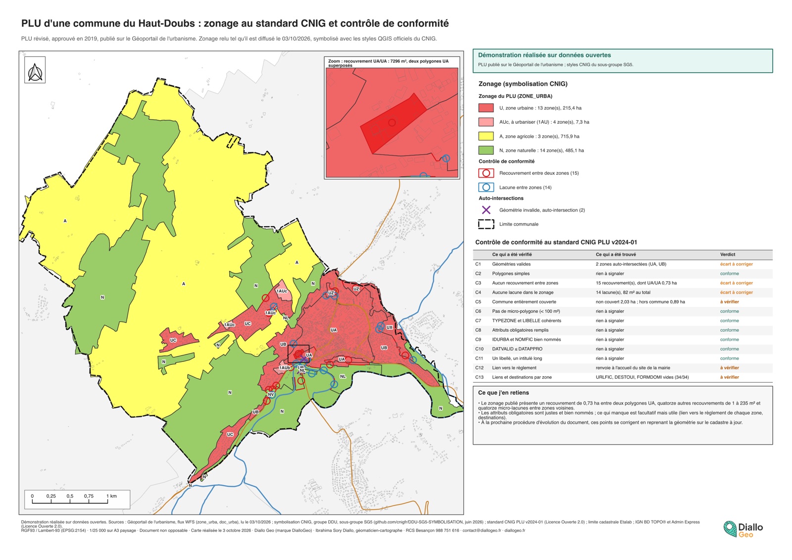
A3 sheet: zoning of a local plan styled to the CNIG standard, overlaps and gaps flagged, table of the 13 compliance checks
Sheet of the demonstration (A3, reduced). In French. Open the image full size
Download the sheet (PDF, in French), 0.6 MB

13checks of the standard: 7 compliant, 3 defects to fix, 3 points to verify

  • Overlaps between zones15including one of 0.73 ha between two UA polygons
  • Gaps between adjacent zones1482 m² in total
  • Invalid geometries2self-intersections (UA, UB)
  • Empty mandatory attributes0LIBELLE, TYPEZONE, NOMFIC and IDURBA are filled in

Still to verify: coverage of the municipality (the cadastre has been updated since), the link to the regulations, which leads to the town hall home page, and the optional fields, left empty. These points are fixed at the next revision of the plan, by redrawing the geometry on the current cadastre.

What I deliver

Limits

The check covers the published data, not the legally binding document held at the town hall. The municipality is not named: the demonstration shows a method, not a judgement on a document.

GIS back-up for your consultancy

I work as a subcontractor: data structuring and quality checks, maps and atlases, in your house style and under your name if you wish. QGIS, GeoPackage and PDF deliverables.

Discuss a project →

Reply within 24 business hours, quote within 3 business days.

← All case studies and demonstrations